2022, decembrie – Raport de proiect PN-III-P1-1.1-PD-2021-0145
Cod proiect: PN-III-P1-1.1-PD-2021-0145
Contractul nr. PD 85 din 19/04/2022
Titlul proiectului: [FLYSURVEY]
Etapă nr. 1
Titlu etapă: [WP1] Investigații și pași preliminari pentru obținerea DFM (model de caracteristici digitale)
Rezumat [Etapă 1, 2022]: Prima etapă a proiectului a constatat într-un proces extins de investigare a literaturii de specialitate și a cercetărilor privind utilizarea tehnologiilor de fotografie digitală LiDAR și Structure-from-Motion (SfM). Pe lângă cercetarea bibliografică, au fost luate măsuri pregătitoare pentru procesul de achiziție a echipamentelor care urmează să înceapă în prima lună a etapei 2 (ianuarie 2023), iar unele proceduri administrative prevăzute în proiect au fost efectuate (de ex. pregătirea paginii web a proiectului). În cadrul acestei etape, a fost finalizată cercetarea unui studiu de caz în care au fost utilizate principiile și obiectivele din metodologia concepută în proiectul Flysurvey. Diseminarea rezultatelor a fost realizată prin publicarea unui articol într-o revistă indexată WoS cu factor de impact (IF), clasată în Q1. În etapele 2 și 3, complexitatea cercetării va crește prin achiziția și implementarea senzorilor și tehnologiilor moderne (sistemul UAV / dronă profesională, senzorul LiDAR și senzorul DJI P1 RGB), în scopul dezvoltării și testării metodologiei inovatoare DFM, conform propunerii de proiect.
***
REZULTATE
Conform ‘Contractului de finanțare’ pentru PD 85, cu data de 04/19/2022, toate activitățile planificate în cadrul proiectului pentru perioada de raportare (04/01/2022-12/31/2022) au fost realizate, cu 100% dintre acestea finalizate.
Rezultate principale: [Articole] Publicarea unui manuscris într-o revistă Q1: Remote Sensing. 2022, 14(22), 5822; https://doi.org/10.3390/rs14225822
(Acest articol aparține numărului special UAVs for Civil Engineering Applications)
Citarea articolului (stiluri de citare):
Stil MDPI și ACS
Sestras, P.; Bilașco, Ș.; Roșca, S.; Veres, I.; Ilies, N.; Hysa, A.; Spalević, V.; Cîmpeanu, S.M. Multi-Instrumental Approach to Slope Failure Monitoring in a Landslide Susceptible Newly Built-Up Area: Topo-Geodetic Survey, UAV 3D Modelling and Ground-Penetrating Radar. Remote Sens. 2022, 14, 5822. https://doi.org/10.3390/rs14225822
Stil AMA
Sestras P, Bilașco Ș, Roșca S, Veres I, Ilies N, Hysa A, Spalević V, Cîmpeanu SM. Multi-Instrumental Approach to Slope Failure Monitoring in a Landslide Susceptible Newly Built-Up Area: Topo-Geodetic Survey, UAV 3D Modelling and Ground-Penetrating Radar. Remote Sensing. 2022; 14(22):5822. https://doi.org/10.3390/rs14225822
Stil Chicago/Turabian
Sestras, Paul, Ștefan Bilașco, Sanda Roșca, Ioel Veres, Nicoleta Ilies, Artan Hysa, Velibor Spalević, and Sorin M. Cîmpeanu. 2022. „Multi-Instrumental Approach to Slope Failure Monitoring in a Landslide Susceptible Newly Built-Up Area: Topo-Geodetic Survey, UAV 3D Modelling and Ground-Penetrating Radar” Remote Sensing 14, no. 22: 5822. https://doi.org/10.3390/rs14225822
Multi-Instrumental Approach to Slope Failure Monitoring in a Landslide Susceptible Newly Built-Up Area: Topo-Geodetic Survey, UAV 3D Modelling and Ground-Penetrating Radar
Paul Sestras 1
Ștefan Bilașco 2,3*
Sanda Roșca 2,
Ioel Veres 1
Nicoleta Ilies 1
Artan Hysa 4
Velibor Spalević 5
Sorin M. Cîmpeanu 6
1 Facultatea de Inginerie Civilă, Universitatea Tehnică din Cluj-Napoca, 400020 Cluj-Napoca, România
2 Facultatea de Geografie, Universitatea Babeș-Bolyai, 400006 Cluj-Napoca, România
3 Secția de Geografie Cluj-Napoca, Academia Română, 400015 Cluj-Napoca, România
4 Facultatea de Arhitectură și Inginerie, Universitatea Epoka, 1000 Tirana, Albania
5 Catedra de Geografie, Facultatea de Filozofie, Universitatea din Muntenegru, 81400 Nikšić, Muntenegru
6 Facultatea de Amenajarea Teritoriului și Inginerie Ecologică, Universitatea de Științe Agronomice și Medicină Veterinară București, 011464 București, România
Rezumat
Cederile de pantă și alunecările de teren provoacă daune economice și decese în întreaga lume. Aceste pierderi pot fi minimizate prin integrarea diferitelor metodologii, instrumente și monitorizarea datelor pentru a prezice viitoarele alunecări de teren. În zona metropolitană în continuă creștere a Cluj-Napoca, România, modificările acoperișului terestru, ale utilizării terenului și ale zonelor construite reprezintă o problemă. Extinderea urbană fără precedent a împins limitele orașului de la Râul Someș către terenuri colinare predispuse la alunecări de teren și eroziune. Acest studiu se concentrează pe o zonă predispusă la alunecări de teren, unde o cedare anterioară de pantă a cauzat pierderi economice semnificative. Acesta combină măsurători topogeodezice, monitorizarea deplasărilor de suprafață cu UAV, analiza spațială GIS, investigații cu radar de penetrare a solului și evaluare geotehnică. Doi ani de date arată că panta suferă o eroziune de suprafață, cu deplasări ale solului de câțiva centimetri. Monitorizarea geodezică a punctelor de control ale zidului de sprijin indică o mică rotație. Îmbinată cu imaginile de profil georadar care arată modificări în straturile de sol și rocă cu o tendință de urcare, s-a dedus că zona suferă de o instabilitate globală. Rezultatele oferă informații valoroase despre dinamica alunecărilor de teren și a eroziunii pentru previziunea viitoarelor mișcări și dezvoltarea strategiilor preventive bazate pe o nouă metodologie care combină instrumentație și tehnici accesibile și răspândite.
Cuvinte-cheie: geodezie; topografie; GNSS; stație totală; eroziune de suprafață; alunecare de teren adâncă; deplasări analiză spațială GIS; geomatică; geotehnică
Remote Sensing 2022, 14(22), 5822; https://doi.org/10.3390/rs14225822
Număr special: UAV-uri pentru aplicații în ingineria civilă
Imagini sugestive privind activitățile și rezultatele obținute, prezentate în articol
***
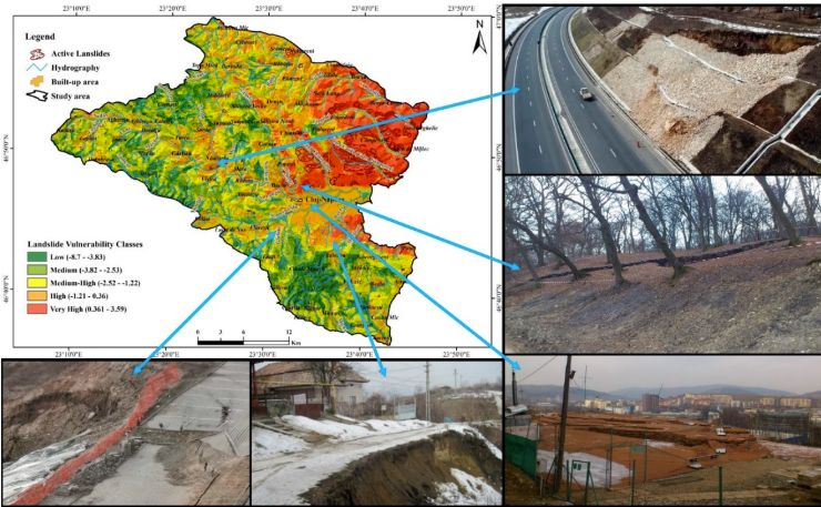
Figura 1. Harta susceptibilității la alunecări de teren [4] cu puncte critice relevante
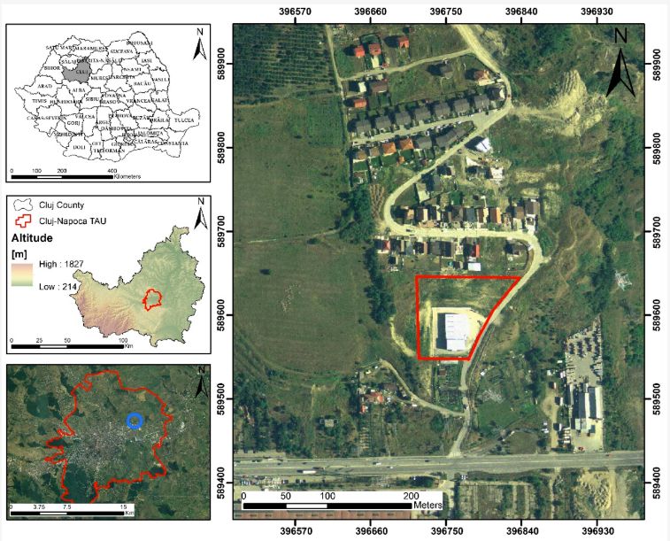
Figura 2. Localizarea geografică a zonei de studiu
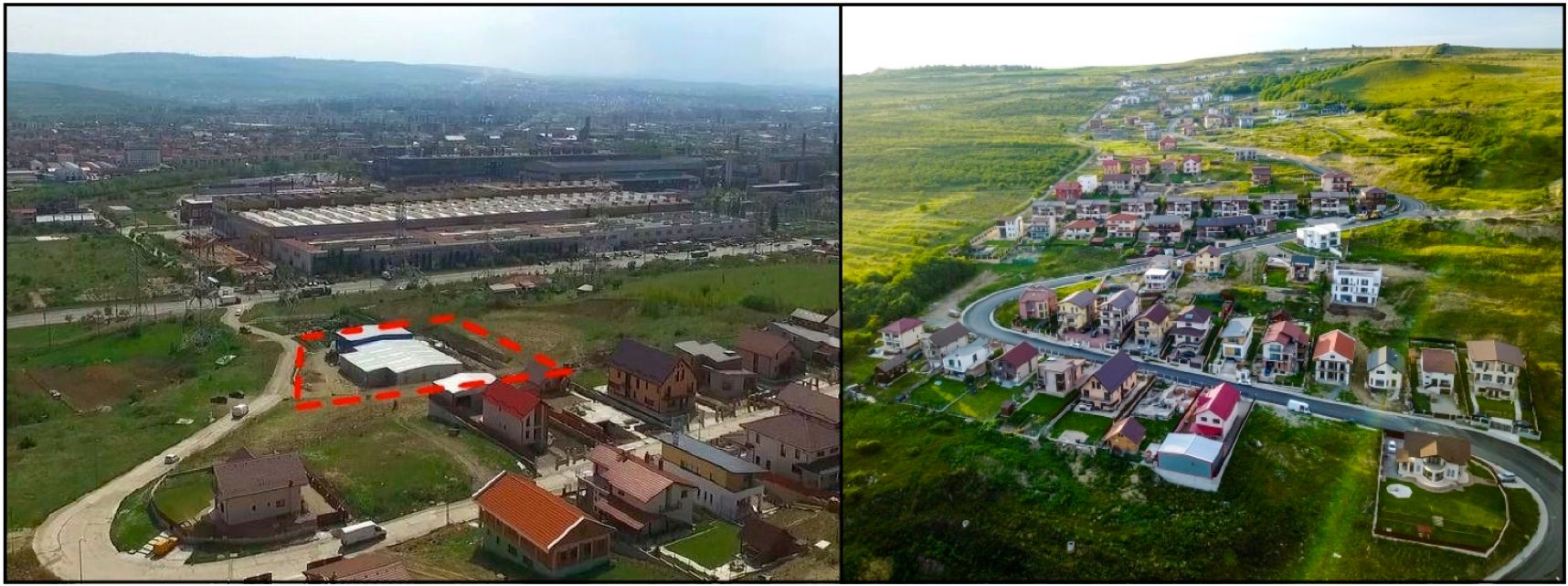
Figura 3. Fotografii aeriene ale complexului rezidențial apărut și ale zonei de studiu monitorizate
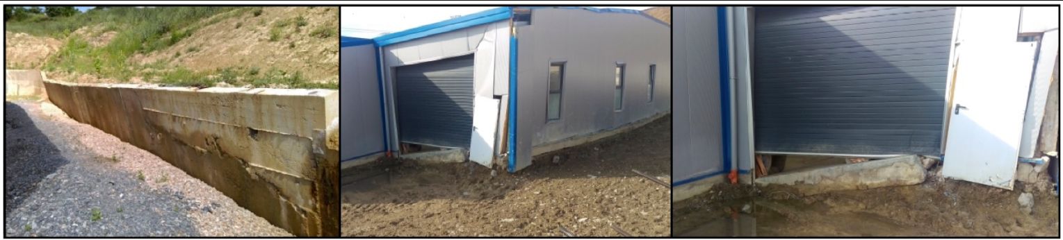
Figura 4. Colaj de imagini care redau vechiul zid de sprijin chiar înainte de cedare și daunele apărute la hala de producție industrială după căderea de teren
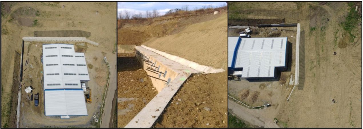 Figura 5. Colaj de imagini care ilustrează zidul de sprijin nou construit și măsurile de ameliorare a terenului.
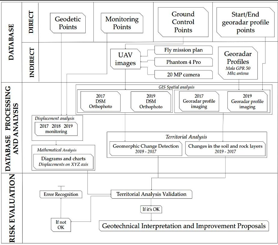
Figura 6. Diagrama de flux metodologică
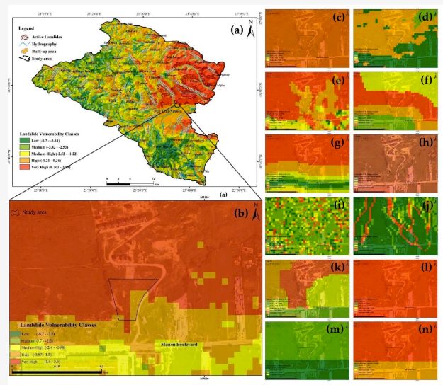
Figura 7. Harta susceptibilității la alunecări de teren din studiul de cercetare anterior [4] (a) și a zonei de studiu (b); cele douăsprezece factori examinați ca factori potențiali de influență asupra mișcării în masă a versantului: altitudinea (c), panta (d), expunerea (e), distanța față de așezări (f), drumuri (g), hidrografie (h), indicele de umiditate (i), indicele de putere a cursului de apă (j), utilizarea terenului (k), geologia (l), adâncimea fragmentării (m) și densitatea fragmentării (n)
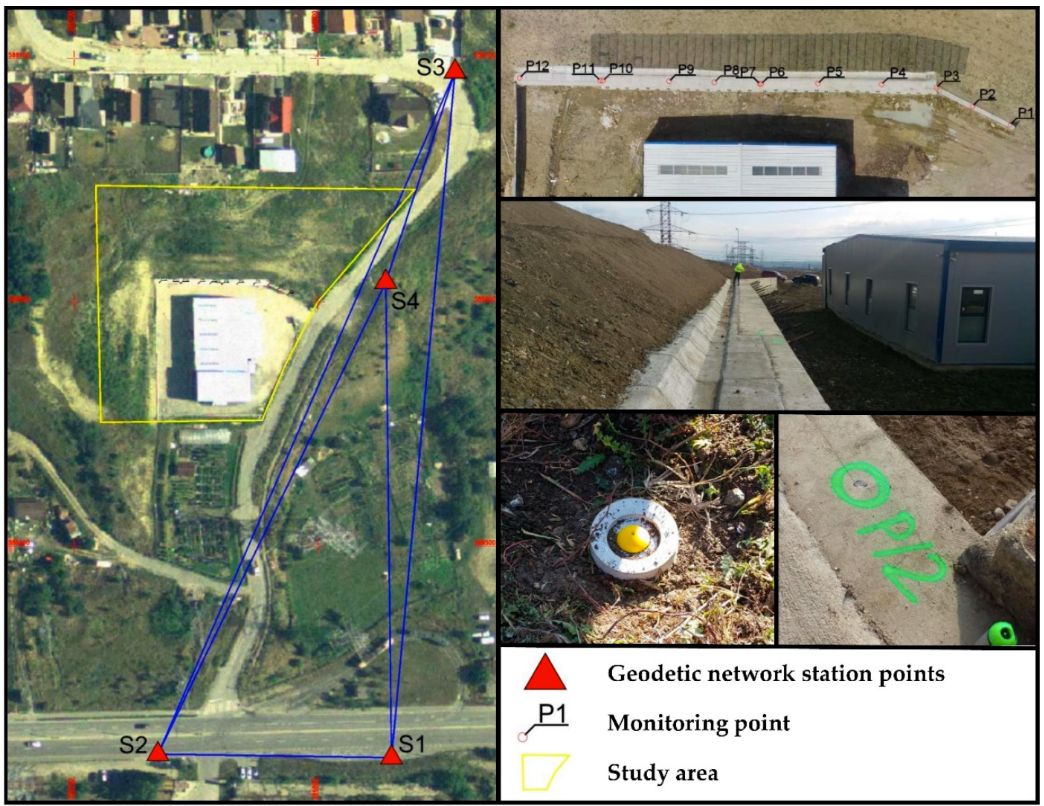
Figura 8. Rețeaua geodezică locală stabilită
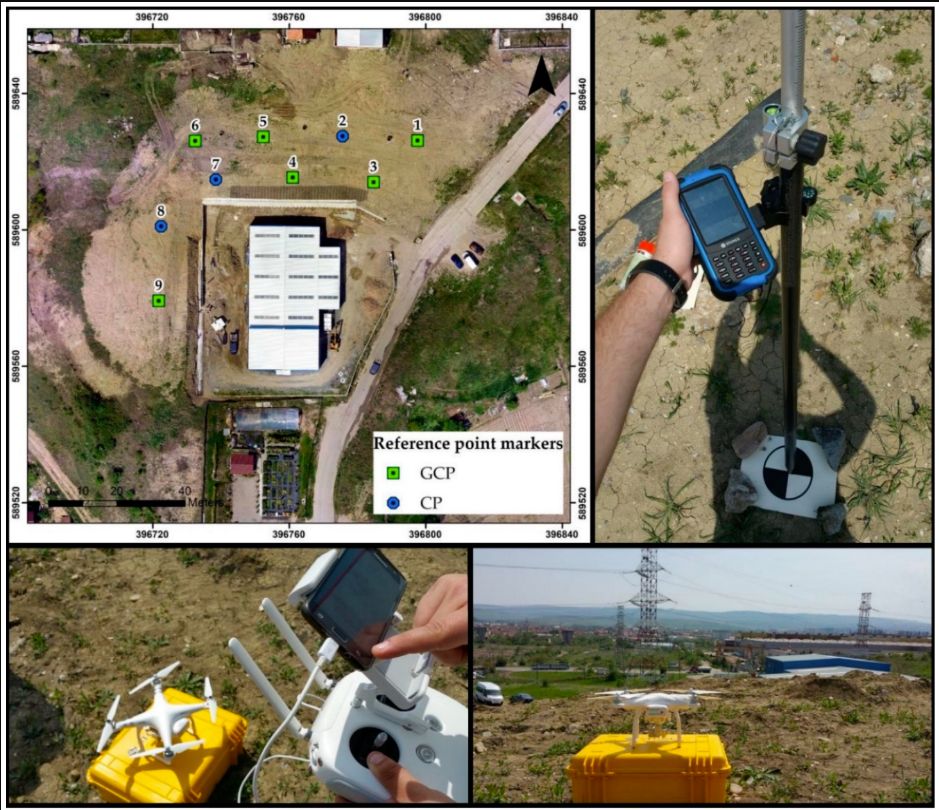
Figura 9. Ortofotografia obținută cu poziționarea GCP și CP și instrumentația utilizată
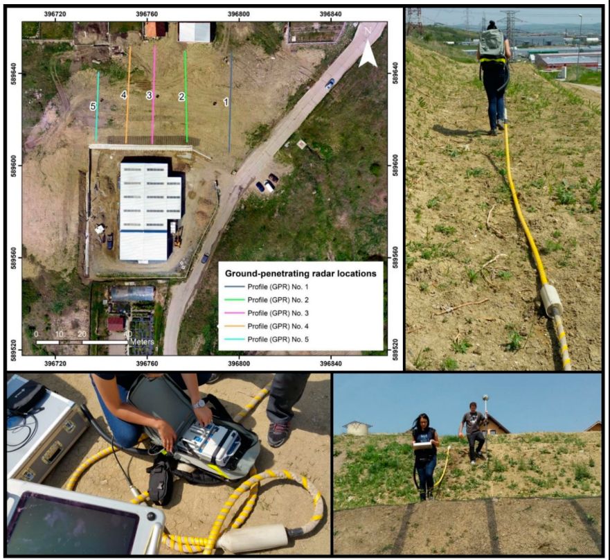
Figura 10. Ortofotografia obținută cu locațiile profilurilor GPR și instrumentația utilizată
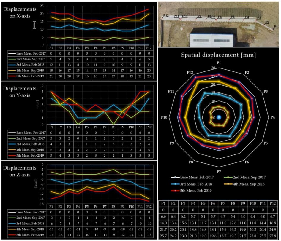
Figura 11. Analiza deplasărilor pe fiecare axă, precum și valorile spațiale globale
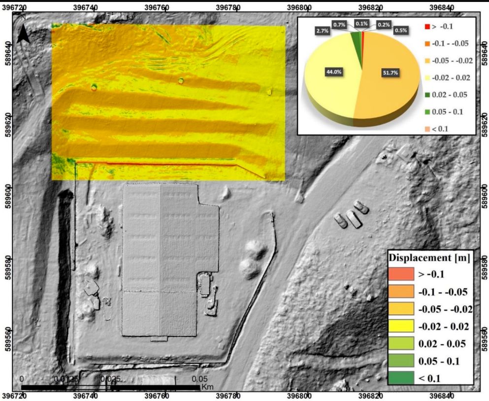
Figura 12. Viteza de mișcare a suprafeței
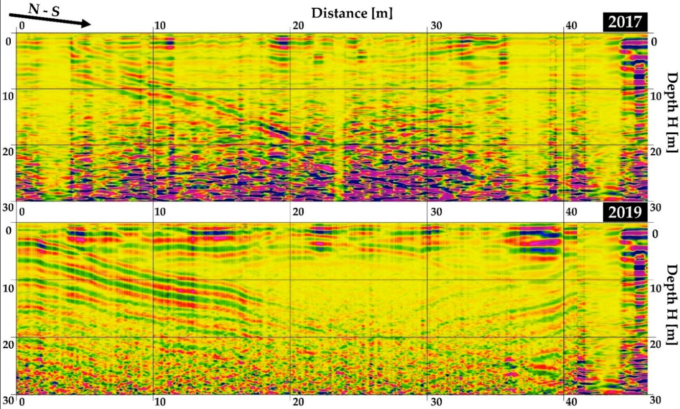
Figura 13. Profil longitudinal GPR
Referințe
- Corpade, C.; Man, T.; Petrea, D.; Corpade, A.-M.; Moldovan, C. Changes in landscape structure induced by transportation projects in Cluj-Napoca periurban area using GIS. Carpathian J. Earth Environ. Sci. 2014, 9, 177–184. [Google Scholar]
- Dolean, B.-E.; Bilașco, Ș.; Petrea, D.; Moldovan, C.; Vescan, I.; Roșca, S.; Fodorean, I. Evaluation of the Built-Up Area Dynamics in the First Ring of Cluj-Napoca Metropolitan Area, Romania by Semi-Automatic GIS Analysis of Landsat Satellite Images. Appl. Sci. 2020, 10, 7722. [Google Scholar] [CrossRef]
- Cebotari, S.; Cristea, M.; Moldovan, C.; Zubașcu, F. Renewable Energy’s Impact on Rural Development in Northwestern Romania. Energy Sustain. Dev. 2017, 37, 110–123. [Google Scholar] [CrossRef]
- Sestras, P.; Bilasco, S.; Roșca, S.; Naș, S.; Bondrea, M.; Gâlgău, R.; Vereș, I.; Salagean, T.; Spalevic, V.; Cimpeanu, S. Landslides Susceptibility Assessment Based on GIS Statistical Bivariate Analysis in the Hills Surrounding a Metropolitan Area. Sustainability 2019, 11, 1362. [Google Scholar] [CrossRef]
- Sestras, P.; Bilașco, Ș.; Roșca, S.; Dudic, B.; Hysa, A.; Spalević, V. Geodetic and UAV Monitoring in the Sustainable Management of Shallow Landslides and Erosion of a Susceptible Urban Environment. Remote Sens. 2021, 13, 385. [Google Scholar] [CrossRef]
- Bilașco, Ș.; Roșca, S.; Fodorean, I.; Vescan, I.; Filip, S.; Petrea, D. Quantitative evaluation of the risk induced by dominant geomorphological processes on different land uses, based on GIS spatial analysis models. Front. Earth Sci. 2018, 12, 311–324. [Google Scholar]
- Bălteanu, D.; Micu, M.; Jurchescu, M.; Malet, J.-P.; Sima, M.; Kucsicsa, G.; Dumitrică, C.; Petrea, D.; Mărgărint, M.C.; Bilașco, S.T.; et al. National-scale landslide susceptibility map of Romania in a European methodological framework. Geomorphology 2020, 371, 107432. [Google Scholar] [CrossRef]
- Kerekes, A.H.; Poszet, S.L.; Andrea, G.Á.L. Landslide susceptibility assessment using the maximum entropy model in a sector of the Cluj–Napoca Municipality, Romania. Rev. Geomorfol. 2018, 20, 130–146. [Google Scholar] [CrossRef]
- Kerekes, A.H.; Poszet, S.L.; Baciu, L.C. Investigating land surface deformation using InSAR and GIS techniques in Cluj–Napoca city’s most affected sector by urban sprawl (Romania). Rev. Geomorfol. 2020, 22, 43–59. [Google Scholar] [CrossRef]
- Roșca, S.; Bilașco, Ș.; Petrea, D.; Fodorean, I.; Vescan, I.; Filip, S. Application of landslide hazard scenarios at annual scale in the Niraj River basin (Transylvania Depression, Romania). Nat. Hazards 2015, 77, 1573–1592. [Google Scholar]
- Galli, M.; Ardizzone, F.; Cardinali, M.; Guzzetti, F.; Reichenbach, P. Comparing landslide inventory maps. Geomorphology 2008, 94, 268–289. [Google Scholar] [CrossRef]
- Cruden, D.M.; Varnes, D.J. Landslides: Investigation and mitigation. Chapter 3-Landslide types and processes. Transp. Res. Board Spec. Rep. 1996, 247, 36–75. [Google Scholar]
- Artese, S.; Perrelli, M. Monitoring a Landslide with High Accuracy by Total Station: A DTM-Based Model to Correct for the Atmospheric Effects. Geosciences 2018, 8, 46. [Google Scholar] [CrossRef]
- Guzzetti, F.; Mondini, A.C.; Cardinali, M.; Fiorucci, F.; Santangelo, M.; Chang, K.T. Landslide inventory maps: New tools for an old problem. Earth Sci. Rev. 2012, 112, 42–66. [Google Scholar] [CrossRef]
- Corominas, J.; van Westen, C.; Frattini, P.; Cascini, L.; Malet, J.-P.; Fotopoulou, S.; Catani, F.; Van Den Eeckhaut, M.; Mavrouli, O.; Agliardi, F.; et al. Recommendations for the quantitative analysis of landslide risk. Bull. Eng. Geol. Environ. 2014, 73, 209–263. [Google Scholar] [CrossRef]
- Stiros, S.C.; Vichas, C.; Skourtis, C. Landslide Monitoring Based on Geodetically Derived Distance Changes. J. Surv. Eng. 2004, 130, 156–162. [Google Scholar] [CrossRef]
- Tsaia, Z.; Youa, G.J.Y.; Leea, H.Y.; Chiub, Y.J. Use of a total station to monitor post-failure sediment yields in landslide sites of the Shihmen reservoir watershed. Geomorphology 2012, 139–140, 438–451. [Google Scholar] [CrossRef]
- Westoby, M.J.; Brasington, J.; Glasser, N.F.; Hambrey, M.J.; Reynolds, J.M. „Structure-from-motion” photogrammetry: A low-cost, effective tool for geoscience applications. Geomorphology 2012, 179, 300–314. [Google Scholar] [CrossRef]
- Turner, D.; Lucieer, A.; De Jong, S.M. Time Series Analysis of Landslide Dynamics Using an Unmanned Aerial Vehicle (UAV). Remote Sens. 2015, 7, 1736–1757. [Google Scholar] [CrossRef]
- Al-Rawabdeh, A.; Moussa, A.; Foroutan, M.; El-Sheimy, N.; Habib, A. Time Series UAV Image-Based Point Clouds for Landslide Progression Evaluation Applications. Sensors 2017, 17, 2378. [Google Scholar] [CrossRef]
- Devoto, S.; Macovaz, V.; Mantovani, M.; Soldati, M.; Furlani, S. Advantages of Using UAV Digital Photogrammetry in the Study of Slow-Moving Coastal Landslides. Remote Sens. 2020, 12, 3566. [Google Scholar] [CrossRef]
- Akca, D. Photogrammetric monitoring of an artificially generated shallow landslide. Photogramm. Rec. 2013, 28, 178–195. [Google Scholar] [CrossRef]
- Jaboyedoff, M.; Oppikofer, T.; Abellán, A.; Derron, M.H.; Loye, A.; Metzger, R.; Pedrazzini, A. Use of LIDAR in landslide investigations: A review. Nat. Hazards 2012, 61, 5–28. [Google Scholar] [CrossRef]
- Dewitte, O.; Jasselette, J.C.; Cornet, Y.; Van Den Eeckhaut, M.; Collignon, A.; Poesen, J.; Demoulin, A. Tracking landslide displacements by multi-temporal DTMs: A combined aerial stereophotogrammetric and LIDAR approach in western Belgium. Eng. Geol. 2008, 99, 11–22. [Google Scholar] [CrossRef]
- Görüm, T. Landslide recognition and mapping in a mixed forest environment from airborne LiDAR data. Eng. Geol. 2019, 258, 105155. [Google Scholar] [CrossRef]
- Syzdykbayev, M.; Karimi, B.; Karimi, H.A. Persistent homology on LiDAR data to detect landslides. Remote Sens. Environ. 2020, 246, 111816. [Google Scholar] [CrossRef]
- Bernat Gazibara, S.; Krkač, M.; Mihalić Arbanas, S. Landslide inventory mapping using LiDAR data in the City of Zagreb (Croatia). J. Maps 2019, 15, 773–779. [Google Scholar] [CrossRef]
- Peduto, D.; Oricchio, L.; Nicodemo, G.; Crosetto, M.; Ripoll, J.; Buxó, P.; Janeras, M. Investigating the kinematics of the unstable slope of Barbera de la Conca (Catalonia, Spain) and the effects on the exposed facilities by GBSAR and multi-source conventional monitoring. Landslides 2021, 18, 457–469. [Google Scholar] [CrossRef]
- Althuwaynee, O.F.; Pradhan, B.; Lee, S. A novel integrated model for assessing landslide susceptibility mapping using CHAID and AHP pair-wise comparison. Int. J. Remote Sens. 2016, 37, 1190–1209. [Google Scholar] [CrossRef]
- Martha, T.R.; Kerle, N.; Jetten, V.; van Westen, C.J.; Kumar, K.V. Landslide volumetric analysis using cartosat-1-derived dems. IEEE Geosci. Remote Sens. Lett. 2010, 7, 582–586. [Google Scholar] [CrossRef]
- Cigna, F.; Bianchini, S.; Casagli, N. How to assess landslide activity and intensity with persistent scatterer interferometry (PSI): The PSI-based matrix approach. Landslides 2012, 10, 267–283. [Google Scholar] [CrossRef]
- Lu, P.; Catani, F.; Tofani, V.; Casagli, N. Quantitative hazard and risk assessment for slow-moving landslides from persistent Scatterer interferometry. Landslides 2014, 11, 685–696. [Google Scholar] [CrossRef]
- Ghorbanzadeh, O.; Didehban, K.; Rasouli, H.; Kamran, K.V.; Feizizadeh, B.; Blaschke, T. An Application of Sentinel-1, Sentinel-2, and GNSS Data for Landslide Susceptibility Mapping. ISPRS Int. J. Geo Inf. 2020, 9, 561. [Google Scholar] [CrossRef]
- Simeoni, L.; Ferro, E.; Tombolato, S. Reliability of Field Measurements of Displacements in Two Cases of Viaduct-Extremely Slow Landslide Interactions. Eng. Geol. Soc. Territ. 2015, 2, 125–128. [Google Scholar]
- Afeni, T.B.; Cawood, F.T. Slope Monitoring using Total Station: What are the Challenges and How Should These be Mitigated? S. Afr. J. Geomat. 2013, 2, 41–53. [Google Scholar]
- Sestras, P. Methodological and On-Site Applied Construction Layout Plan with Batter Boards Stake-Out Methods Comparison: A Case Study of România. Appl. Sci. 2021, 11, 4331. [Google Scholar] [CrossRef]
- Salagean, T.; Rusu, T.; Onose, D.; Farcas, R.; Duda, B.; Sestras, P. Utilizarea tehnologiei de scanare laser în monitorizarea terenului în zonele miniere. Carpathian J. Earth Environ. Sci. 2016, 11, 565573. [Google Scholar]
- Song, Y.; Wu, P. Observația Pământului pentru Infrastructură Sustenabilă: O Recenzie. Remote Sens. 2021, 13, 1528. [Google Scholar] [CrossRef]
- Sestras, P.; Roșca, S.; Bilașco, Ș.; Naș, S.; Buru, S.M.; Kovacs, L.; Spalević, V.; Sestras, A.F. Evaluări de fezabilitate folosind tehnologia vehiculelor aeriene fără pilot în clădiri patrimoniale: Reabilitare-Restaurare, Analiză Spațială și Analiza Potențialului Turistic. Sensors 2020, 20, 2054. [Google Scholar] [CrossRef]
- Solazzo, D.; Sankey, J.B.; Sankey, T.T.; Munson, S.M. Cartografierea și măsurarea dunelor de nisip eolian prin fotogrametrie și LiDAR de la vehicule aeriene fără pilot (UAV) și imagini satelitare multispectrale pe Platoul Paria, AZ, SUA. Geomorphology 2018, 319, 174–185. [Google Scholar] [CrossRef]
- Oniga, V.-E.; Breaban, A.-I.; Pfeifer, N.; Chirila, C. Determining the Suitable Number of Ground Control Points for UAS Images Georeferencing by Varying Number and Spatial Distribution. Remote Sens. 2020, 12, 876. [Google Scholar] [CrossRef]
- Oniga, V.-E.; Breaban, A.-I.; Pfeifer, N.; Diac, M. 3D Modeling of Urban Area Based on Oblique UAS Images—An End-to-End Pipeline. Remote Sens. 2022, 14, 422. [Google Scholar] [CrossRef]
- Glira, P.; Pfeifer, N.; Mandlburger, G. Hybrid Orientation of Airborne Lidar Point Clouds and Aerial Images. ISPRS Ann. Photogramm. Remote Sens. Spat. Inf. Sci. 2019, 4, 567–574. [Google Scholar] [CrossRef]
- Bandini, F.; Sunding, T.P.; Linde, J.; Smith, O.; Jensen, I.K.; Köppl, C.J.; Bauer-Gottwein, P. Unmanned Aerial System (UAS) observations of water surface elevation in a small stream: Comparison of radar altimetry, LIDAR and photogrammetry techniques. Remote Sens. Environ. 2020, 237, 111487. [Google Scholar] [CrossRef]
- Cramer, M.; Haala, N.; Laupheimer, D.; Mandlburger, G.; Havel, P. Ultra-High Precision UAV-Based Lidar and Dense Image Matching. În Proceedings of the ISPRS TC I Mid-term Symposium “Innovative Sensing—From Sensors to Methods and Applications”, Karlsruhe, Germania, 10–12 octombrie 2018. [Google Scholar]
- Pirasteh, S.; Li, J. Landslides investigations from geoinformatics perspective: Quality, challenges, and recommendations. Geomatics, Nat. Hazards Risk 2017, 8, 448–465. [Google Scholar] [CrossRef]
- Lissak, C.; Maquaire, O.; Malet, J.P.; Lavigne, F.; Virmoux, C.; Gomez, C.; Davidson, R. Ground-penetrating radar observations for estimating the vertical displacement of rotational landslides. Nat. Hazards Earth Syst. Sci. 2015, 15, 1399–1406. [Google Scholar] [CrossRef]
- Qi, L.; Tan, W.; Huang, P.; Xu, W.; Qi, Y.; Zhang, M. Landslide Prediction Method Based on a Ground-Based Micro-Deformation Monitoring Radar. Remote Sens. 2020, 12, 1230. [Google Scholar] [CrossRef]
- Hussain, Y.; Cardenas-Soto, M.; Martino, S.; Moreira, C.; Borges, W.; Hamza, O.; Prado, R.; Uagoda, R.; Rodríguez-Rebolledo, J.; Silva, R.C.; et al. Multiple Geophysical Techniques for Investigation and Monitoring of Sobradinho Landslide, Brazil. Sustainability 2019, 11, 6672. [Google Scholar] [CrossRef]
- Verbovšek, T.; Košir, A.; Teran, M.; Zajc, M.; Popit, T. Volume determination of the Selo landslide complex (SW Slovenia): Integrating field mapping, ground penetrating radar and GIS approaches. Landslides 2017, 14, 1265–1274. [Google Scholar] [CrossRef]
- Barnhardt, W.A.; Kayen, R.E. Radar structure of earthquake-induced, coastal landslides in Anchorage, Alaska. Environ. Geosci. 2000, 7, 38–45. [Google Scholar] [CrossRef]
- Bichler, A.; Bobrowsky, P.; Best, M.; Douma, M.; Hunter, J.; Calvert, T.; Burns, R. Three-dimensional mapping of a landslide using a multi-geophysical approach: The Quesnel Forks landslide. Landslides 2004, 1, 29–40. [Google Scholar] [CrossRef]
- Sass, O.; Bell, R.; Glade, T. Comparison of GPR, 2D-resistivity and traditional techniques for the subsurface exploration of the Öschingen landslide, Swabian Alb (Germany). Geomorphology 2008, 93, 89–103. [Google Scholar] [CrossRef]
- Mantovani, M.; Devoto, S.; Forte, E.; Mocnik, A.; Pasuto, A.; Piacentini, D.; Soldati, M. A multidisciplinary approach for rock spreading and block sliding investigation in the north-western coast of Malta. Landslides 2013, 10, 611–622. [Google Scholar] [CrossRef]
- Kadioglu, S.; Ulugergerli, E.U. Imaging karstic cavities in transparent 3D volume of the GPR data set in Akkopru dam, Mugla, Turkey. Nondestruct. Test. Eval. 2012, 27, 263–271. [Google Scholar] [CrossRef]
- Kannaujiya, S.; Chattoraj, S.L.; Jayalath, D.; Bajaj, K.; Podali, S.; Bisht, M.P.S. Integration of satellite remote sensing and geophysical techniques (electrical resistivity tomography and ground penetrating radar) for landslide characterization at Kunjethi (Kalimath), Garhwal Himalaya, India. Nat. Hazards 2019, 97, 1191–1208. [Google Scholar] [CrossRef]
- Șerban, G.; Rus, I.; Vele, D.; Brețcan, P.; Alexe, M.; Petrea, D. Flood-prone area delimitation using UAV technology, in the areas hard-to-reach for classic aircrafts: Case study in the north-east of Apuseni Mountains, Transylvania. Nat. Hazards 2016, 82, 1817–1832. [Google Scholar] [CrossRef]
- Hysa, A.; Spalevic, V.; Dudic, B.; Roșca, S.; Kuriqi, A.; Bilașco, Ș.; Sestras, P. Utilizing the Available Open-Source Remotely Sensed Data in Assessing the Wildfire Ignition and Spread Capacities of Vegetated Surfaces in Romania. Remote Sens. 2021, 13, 2737. [Google Scholar] [CrossRef]
- Matei, I.; Pacurar, I.; Rosca, S.; Bilasco, S.; Sestras, P.; Rusu, T.; Jude, E.T.; Tăut, F.D. Land Use Favourability Assessment Based on Soil Characteristics and Anthropic Pollution. Case Study Somesul Mic Valley Corridor, Romania. Agronomy 2020, 10, 1245. [Google Scholar] [CrossRef]
- Fîrțală-Cioncuț, A.; Bilașco, S.; Fodorean, I.; Roșca, S.; Vescan, I. Identificarea și evaluarea riscului indus de alunecări de teren pe baza modelelor G.I.S. de analiză spațială. Studiu de caz: Bicazu Ardelean, România. Nova Geodesia 2022, 3, 52. [Google Scholar] [CrossRef]
- Jaedicke, C.; Van Den Eeckhaut, M.; Nadim, F.; Hervás, J.; Kalsnes, B.; Vangelsten, B.V.; Smith, J.T.; Tofani, V.; Ciurean, R.; Winter, M.G. Identificarea ‘hotspots’ de pericol și risc de alunecări de teren în Europa. Bull. Eng. Geol. Environ. 2014, 73, 325–339. [Google Scholar] [CrossRef]
- Jebur, M.N.; Pradhan, B.; Shafri, H.Z.M.; Yusoff, Z.M.; Tehrany, M.S. Un instrument integrat, ușor de utilizat, ArcMAP, pentru modelarea statistică bivariată în aplicații de geoinformatică. Geosci. Model Dev. 2015, 8, 881–891. [Google Scholar] [CrossRef]
- Chalkias, C.; Ferentinou, M.; Polykretis, C. Modelarea susceptibilității la alunecări de teren, susținută de GIS, la scară regională: O metodă de ponderare fuzzy bazată pe expertiză. ISPRS Int. J. Geo Inf. 2014, 3, 523–539. [Google Scholar] [CrossRef]
- Vakhshoori, V.; Zare, M. Is the ROC curve a reliable tool to compare the validity of landslide susceptibility maps? Geomat. Nat. Hazards Risk 2018, 9, 249–266. [Google Scholar] [CrossRef]
- Borrelli, L.; Ciurleo, M.; Gullà, G. Shallow Landslide Susceptibility Assessment in Granitic Rocks Using Gis-Based Statistical Methods: The Contribution of the Weathering Grade Map. Landslides 2018, 15, 1127–1142. [Google Scholar] [CrossRef]
- Ciurleo, M.; Cascini, L.; Calvello, M. A comparison of statistical and deterministic methods for shallow landslide susceptibility zoning in clayey soils. Eng. Geol. 2017, 223, 71–81. [Google Scholar] [CrossRef]
- Pelzer, H. Zur Analyse Geodatischer Deformations-Messungen; Verlag der Bayer. Akad. d. Wiss.: München, Germania, 1971; Volume 164. [Google Scholar]
- Baarda, W. A Testing Procedure for Use in Geodetic Networks; Rijkscommissie Voor Geodesie: Delft, Olanda, 1968; Volume 2. [Google Scholar]
- Chrzanowski, A. Optimization of the breakthrough accuracy in tunneling surveys. Can. Surv. 1981, 35, 5–16. [Google Scholar] [CrossRef]
- Chrzanowski, A.; Chen, Y.; Romero, P.; Secord, J.M. Integration of geodetic and geotechnical deformation surveys in the geosciences. Tectonophysics 1986, 130, 369–383. [Google Scholar] [CrossRef]
- Kersten, T.; Kobe, M.; Gabriel, G.; Timmen, L.; Schön, S.; Vogel, D. Geodetic monitoring of sub erosion-induced subsidence processes in urban areas. J. Appl. Geod. 2017, 11, 21–29. [Google Scholar]
- Hassan, K.M.Z. Comparative evaluation among various robust estimation methods in deformation analysis. Spat. Inf. Res. 2016, 24, 485–492. [Google Scholar] [CrossRef]
- Bilașco, Ș.; Hognogi, G.-G.; Roșca, S.; Pop, A.-M.; Iuliu, V.; Fodorean, I.; Marian-Potra, A.-C.; Sestras, P. Flash Flood Risk Assessment and Mitigation in Digital-Era Governance Using Unmanned Aerial Vehicle and GIS Spatial Analyses Case Study: Small River Basins. Remote Sens. 2022, 14, 2481. [Google Scholar] [CrossRef]
- Akturk, E.; Altunel, A.O. Accuracy assesment of a low-cost UAV derived digital elevation model (DEM) in a highly broken and vegetated terrain. Measurement 2019, 136, 382–386. [Google Scholar] [CrossRef]
- Gong, C.; Lei, S.; Bian, Z.; Liu, Y.; Zhang, Z.; Cheng, W. Analysis of the development of an erosion gully in an open-cast coal mine dump during a winter freeze-thaw cycle by using low-cost UAVs. Remote Sens. 2019, 11, 1356. [Google Scholar] [CrossRef]
- Han, X.; Thomasson, J.A.; Xiang, Y.; Gharakhani, H.; Yadav, P.K.; Rooney, W.L. Multifunctional Ground Control Points with a Wireless Network for Communication with a UAV. Sensors 2019, 19, 2852. [Google Scholar] [CrossRef] [PubMed]
- Lendzioch, T.; Langhammer, J.; Jenicek, M. Estimating Snow Depth and Leaf Area Index Based on UAV Digital Photogrammetry. Sensors 2019, 19, 1027. [Google Scholar] [CrossRef] [PubMed]
- Okeson, T.J.; Barrett, B.J.; Arce, S.; Vernon, C.A.; Franke, K.W.; Hedengren, J.D. Achieving Tiered Model Quality in 3D Structure from Motion Models Using a Multi-Scale View-Planning Algorithm for Automated Targeted Inspection. Sensors 2019, 19, 2703. [Google Scholar] [CrossRef] [PubMed]
- Cignetti, M.; Godone, D.; Wrzesniak, A.; Giordan, D. Structure from Motion Multisource Application for Landslide Characterization and Monitoring: The Champlas du Col Case Study, Sestriere, North-Western Italy. Sensors 2019, 19, 2364. [Google Scholar] [CrossRef]
- Leary, R.J.; Hensleigh, J.W.; Wheaton, D.J.M.; Demeurichy, K.D. Recommended Geomorphic Change Detection Procedures for Repeat TLS Surveys from Hells Canyon, Idaho; Utah State University: Logan, UT, USA, 2012. [Google Scholar]
- Xie, P.; Wen, H.; Xiao, P. Evaluation of ground-penetrating radar (GPR) and geology survey for slope stability study in mantled karst region. Environ. Earth Sci. 2018, 77, 122. [Google Scholar] [CrossRef]
- Hallal, N.; Yelles Chaouche, A.; Hamai, L.; Lamali, A.; Dubois, L.; Mohammedi, Y.; Hamidatou, M.; Djadia, L.; Abtout, A. Spatiotemporal evolution of the El Biar landslide (Algiers): New field observation data constrained by ground-penetrating radar investigations. Bull. Eng. Geol. Environ. 2019, 78, 5653–5670. [Google Scholar] [CrossRef]
- Costea, A.; Bilasco, S.; Irimus, I.-A.; Rosca, S.; Vescan, I.; Fodorean, I.; Sestras, P. Evaluation of the Risk Induced by Soil Erosion on Land Use. Case Study: Guruslău Depression. Sustainability 2022, 14, 652. [Google Scholar] [CrossRef]
- Bilașco, Ș.; Roșca, S.; Vescan, I.; Fodorean, I.; Dohotar, V.; Sestras, P. A GIS-Based Spatial Analysis Model Approach for Identification of Optimal Hydrotechnical Solutions for Gully Erosion Stabilization. Case Study. Appl. Sci. 2021, 11, 4847. [Google Scholar] [CrossRef]
- Spalevic, V.; Barovic, G.; Vujacic, D.; Curovic, M.; Behzadfar, M.; Djurovic, N.; Dudic, B.; Billi, P. The Impact of Land Use Changes on Soil Erosion in the River Basin of Miocki Potok, Montenegro. Water 2020, 12, 2973. [Google Scholar] [CrossRef]
- Chalise, D.; Kumar, L.; Spalevic, V.; Skataric, G. Estimation of Sediment Yield and Maximum Outflow Using the IntErO Model in the Sarada River Basin of Nepal. Water 2019, 11, 952. [Google Scholar] [CrossRef]
- Nikolic, G.; Spalevic, V.; Curovic, M.; Khaledi Darvishan, A.; Skataric, G.; Pajic, M.; Kavian, A.; Tanaskovik, V. Variability of Soil Erosion Intensity Due to Vegetation Cover Changes: Case Study of Orahovacka Rijeka, Montenegro. Not. Bot. Horti Agrobot. Cluj Napoca 2018, 47, 237–248. [Google Scholar] [CrossRef]
- Gocić, M.; Dragićević, S.; Radivojević, A.; Martić Bursać, N.; Stričević, L.; Đorđević, M. Changes in Soil Erosion Intensity Caused by Land Use and Demographic Changes in the Jablanica River Basin, Serbia. Agriculture 2020, 10, 345. [Google Scholar] [CrossRef]
***